|
This web page is prepared for providing research materials of our project on mental map preservation in annotating metro maps.
|
Mental map preservation in metro maps |
|
Metro maps serve as the common media for travelers to explore the transportation networks of the metro lines available in major cities.
Such maps are often transformed into schematic diagrams for better readability of the network topology.
Recent advancement of practical techniques enables to automatically schematize geographical layouts of metro networks in a visually plausible fashion.
Properly labeling station names on the schematic metro maps is also important,
while this usually incurs additional technical challenges.
This is primarily because the central downtown area of such a schematic map is usually congested with multiple metro lines around the interchange stations and thus we cannot find enough space for labeling station names, when compared with sparse rural areas around the terminals of the metro lines.
The problem is often alleviated by manually sparing more labeling space around the stations in the congested downtown areas,
which usually incurs a lengthy trial and error process.
It is also infeasible to optimize the layout of the metro network and placement of station names simultaneously because we have to enumerate an excessive number of possible solutions for this combinatorial problem in this case.
In this project, we developed a progressive approach for automatically annotating stations with their names while maximally respecting the original layout of the schematic metro map. For this purpose, we properly preserve the underlying mental map of the original schematic metro map by imposing additional constraints to restrict the variation in the aspect ratios of the regions confined by the metro network. The feasibility of the proposed approach has been demonstrated by presenting experimental results together with the evaluation through a user study. |
Results |
|
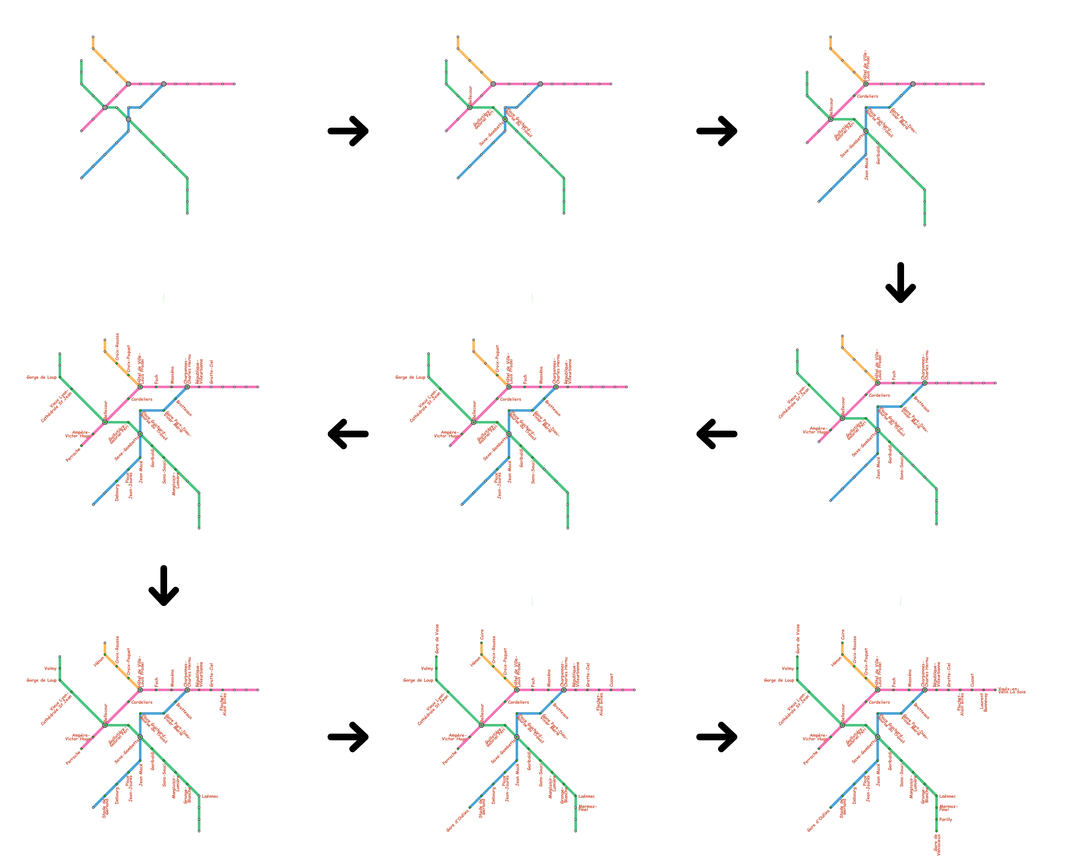
Fig. 1 presents a sequence of the metro maps of Lyon,
in which the proposed approach progressively introduces station name labels one by one,
from the central downtown area to the exterior rural areas.
The results show that the approach can spare additional labeling space for around the next station to be annotated by elongating the metro network edges while retaining their original directions.
|
|
|
Fig. 1: Progressive label placement on the Lyon metro map
|
|
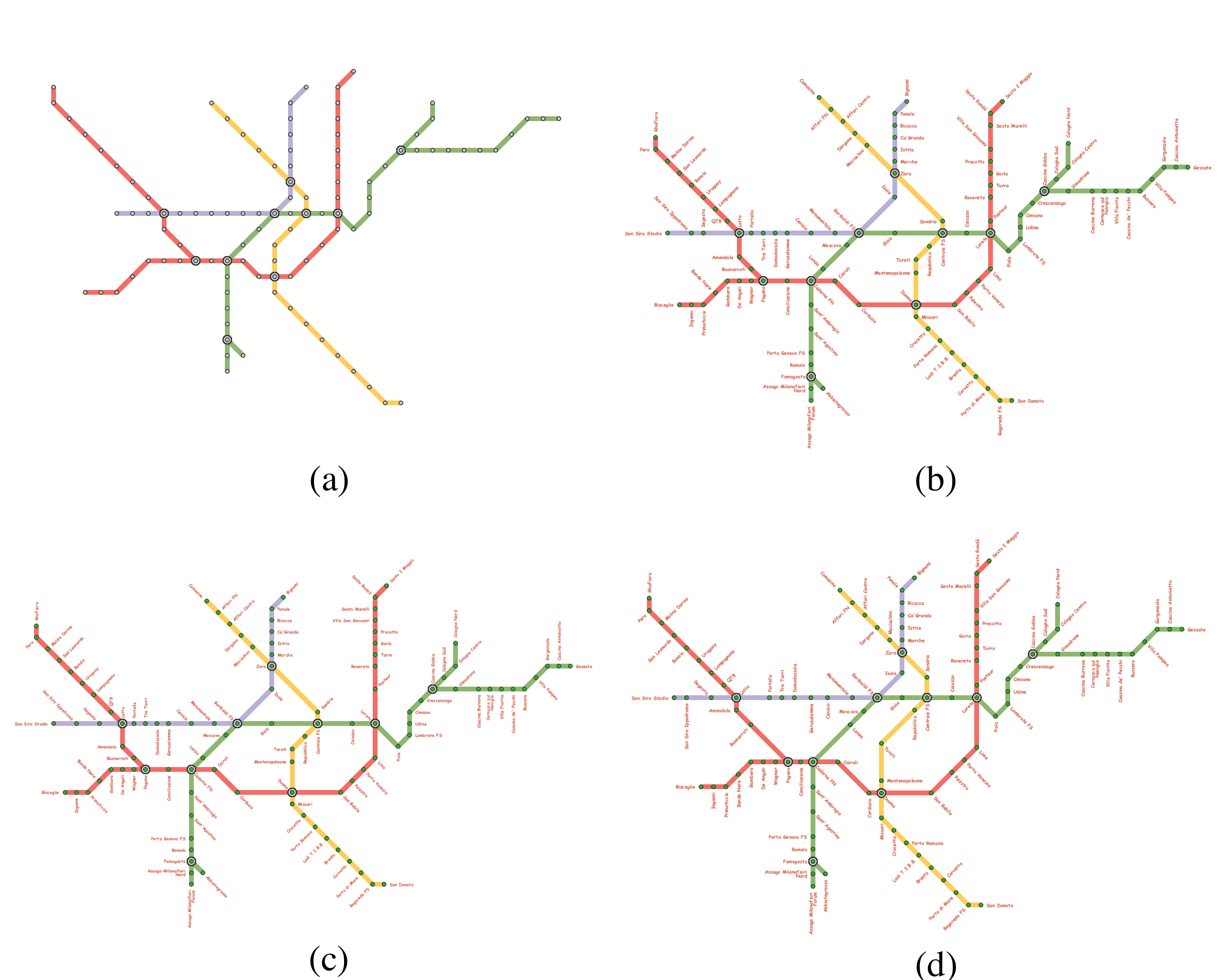
Figs. 2, 3, and 4 demonstrate how the proposed set of constraints preserves the underlying mental map of the respective metro maps in major cities.
In the case of the Milan metro map in Fig. 2, the progressive annotation again stretched the metro map along the horizontal direction while constraints for preserving the mental map reproduce the aspect ratios of the closed regions in the original schematic layout. |
|
|
Fig. 2: Milan metro map.
(a) Original schematic map.
(b) Annotated map without any constraints.
Annotated maps in which the error in the aspect ratios of closed regions is constrained to be (c) less than 50 % and (d) less than 10%.
|
|
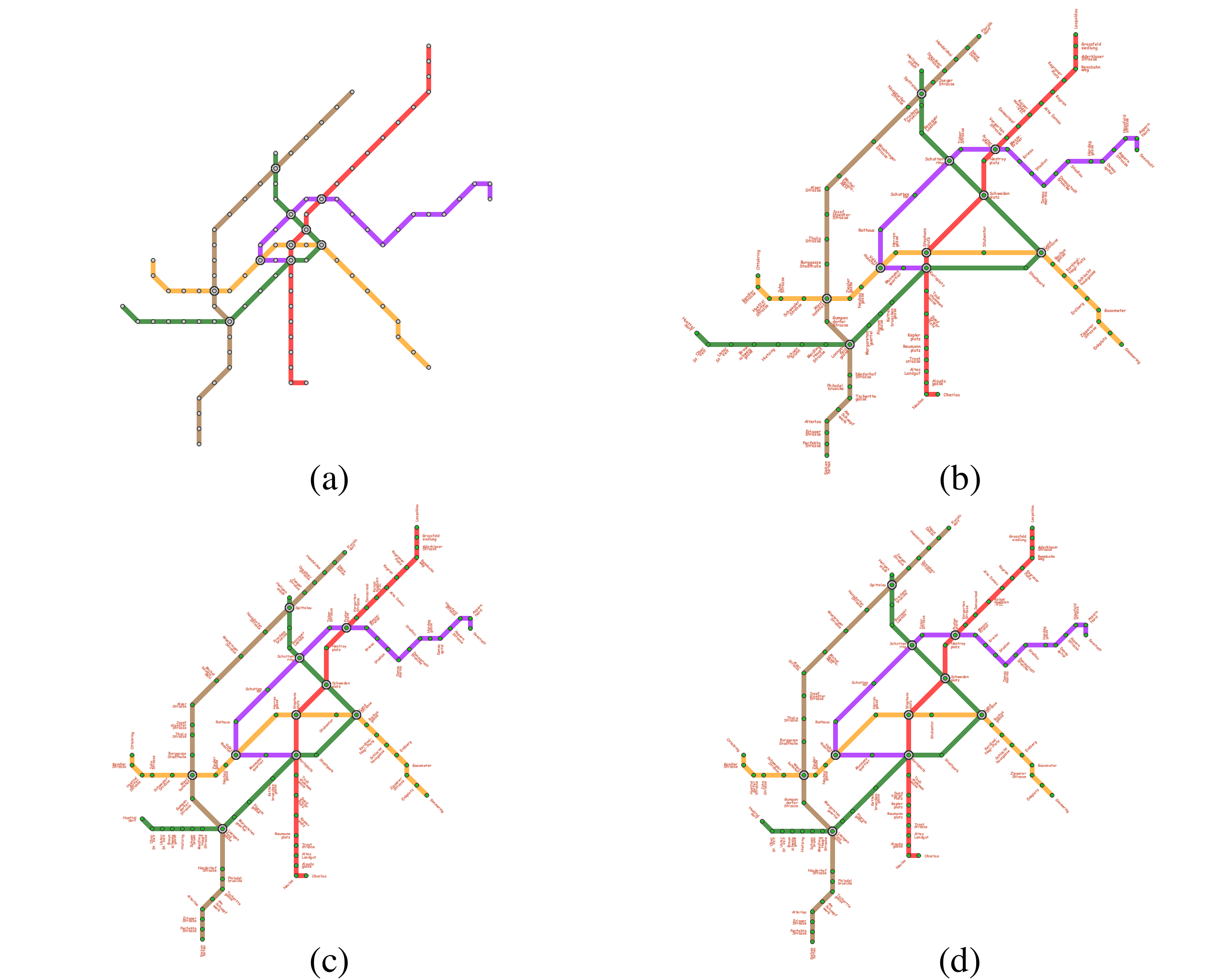
Fig. 3 presents the Vienna metro map, in which the network layout in the central downtown area is strongly distorted when we annotate stations without any specific constraints.
This undesirable deformation is again minimized thanks to the constraints that preserve the aspect ratios of the closed regions confined by the network.
|
|
|
Fig. 3: Vienna metro map.
(a) Original schematic map.
(b) Annotated map without any constraints.
Annotated maps in which the error in the aspect ratios of closed regions is constrained to be (c) less than 50 % and (d) less than 10%.
|
|
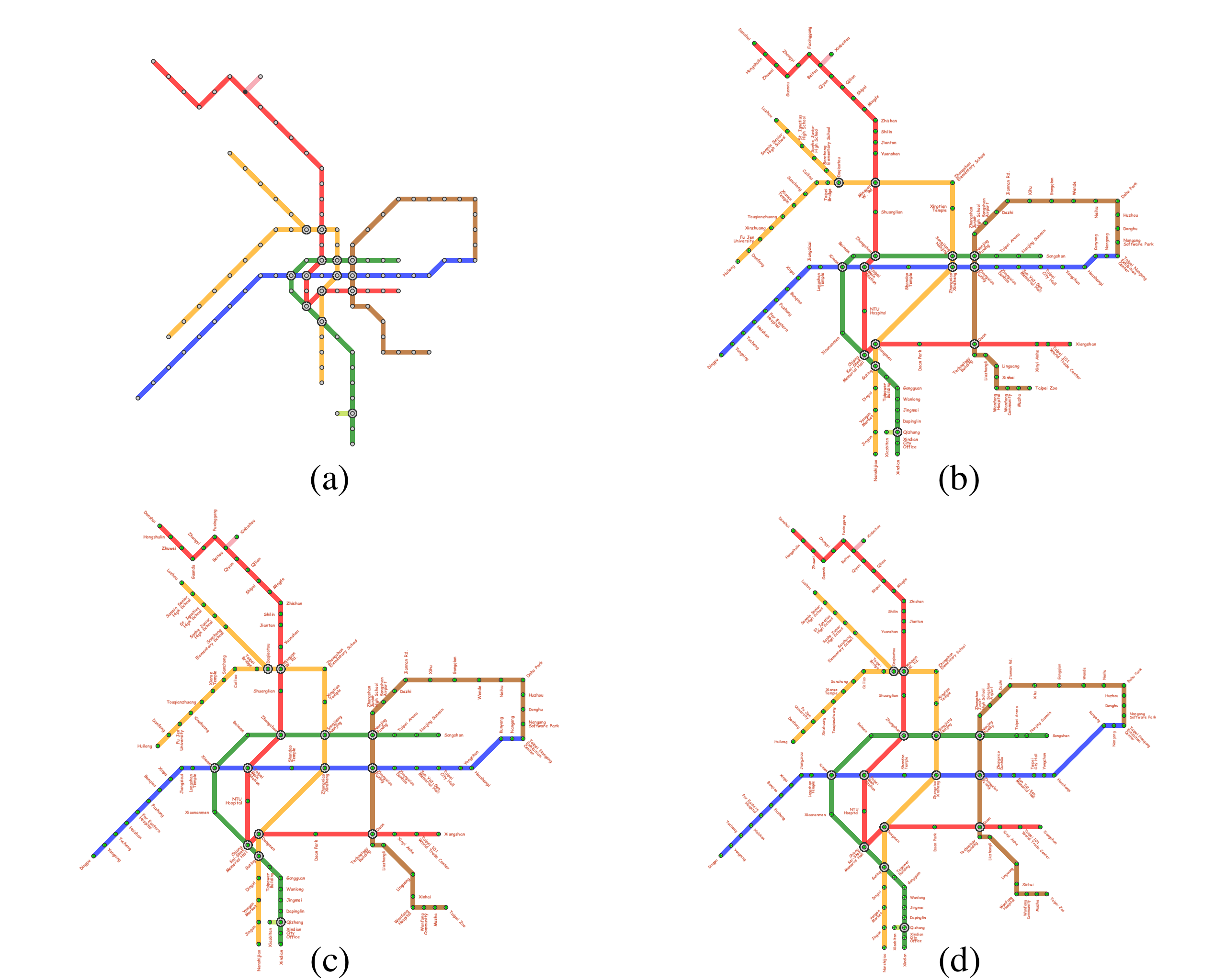
Another drastic change in the layout can be found in the annotated version of the Taipei metro map as shown in Fig. 4,
in which the spaces between the metro lines in parallel cannot be preserved.
Also, in this case, such unacceptable changes in the layout can be avoided using the proposed formulation for keeping the underlying mental map.
|
|
|
Fig. 4: Taipei metro map.
(a) Original schematic map.
(b) Annotated map without any constraints.
Annotated maps in which the error in the aspect ratios of closed regions is constrained to be (c) less than 50 % and (d) less than 10%.
|
|
Fig. 5 provides a demonstration video that presents how we can preserve the underlying mental map of the metro layout during the progressive annotation.
|
|
Fig. 5: Video demonstrating how we can preserve the underlying mental map of the metro layout during the progressive annotation.
|
User Study |
|
To evaluate the feasibility of the proposed formulation for preserving the mental map,
we recruited 54 participants to conduct an informal user study.
The participants were assumed to have the standard or corrected visual acuity while not specifically familiar with the fundamentals of visualization research.
They were then requested to compare the original schematic layout of the synthesized metro map with the three annotated versions and select from the three the best match for the underlying mental map of the original schematic layout.
Here, the three annotated layouts are those obtained with (A) no constraints for preserving the aspect ratios of closed regions,
(B) constraints with the tolerance error ratio of less than 50%
and (C) constraints with the tolerance error ratio of less than 10%.
Table 1 presents the results of the informal user study.
According to the results,
the participants liked the annotated layouts optimized with newly formulated constraints in the three cases, including the metro maps in Milan, Vienna, and Taipei.
In particular,
for the metro maps in Milan and Taipei,
the participates prefer the small error tolerance ratio that strictly preserves the aspect ratios of closed regions in the central downtown area.
However,
they did not discriminate the constrained version with different error tolerance ratios for the metro maps in Vienna.
This is probably because the difference between the two versions is small and the severe constraints sometimes a little excessively enlarge the closed regions to suffice the given conditions.
|
| City | (A) No constraints | (B) error ratio of less than 50% | (C) error ratio of less than 10% |
|---|---|---|---|
| Milan | 9 | 10 | 35 |
| Vienna | 1 | 45 | 7 |
| Taipei | 9 | 13 | 32 |
Paper & VideoShigeo Takahashi, Ken Maruyama, Takamasa Kawagoe, Hsiang-Yun Wu, Kazuo Misue, and Masatoshi Arikawa, Mental Map Preservation for Progressively Labeling Railway Networks, International Journal of Art, Culture and Design Technologies, Vol. 8, No. 1, pp. 31-50, 2019. [PDF], [DOI: 10.4018/IJACDT.2019010103]. |